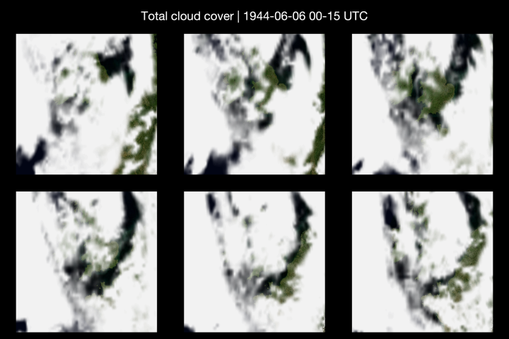
Thick cloud hung over France and the Channel on the morning of D-Day as one of the largest and most dangerous seaborne invasions in history got underway, newly built satellite-style images reveal.
Created ahead of the release of Working Title and STUDIOCANAL’S new film Pressure, scientists have turned weather records from 1944 into an image that looks like a satellite image. The picture recreates what the world might have looked like from space as 160,000 troops crossed the Channel and stormed the beaches of Normandy, a mission that could have failed had the weather not cleared in time.
Professor Ed Hawkins, climate scientist at the University of Reading, co-created the images with scientists from ECMWF, the European Centre for Medium-Range Weather Forecasts.
The images were built using old weather readings fed into a modern weather reconstruction updating data from ERA5, the fifth generation ECMWF reanalysis for the global climate and weather, which fills in the gaps between real measurements to recreate a full picture of the sky.
The remarkable true story behind the weather forecast that helped shape history is the focus of Working Title and STUDIOCANAL’s forthcoming film Pressure. Starring Andrew Scott as Group Captain James Stagg, the meteorologist who advised Supreme Allied Commander General Dwight D. Eisenhower, and Brendan Fraser as Eisenhower, the film explores the pivotal decision to delay the Allied invasion.
Professor Hawkins said: “Troops set off into a sky that was still breaking up after days of storms into a narrow window of better weather. A day earlier, or a few hours either way, and the weather could have stopped the invasion in its tracks, and changed the outcome of the war.
“Images like this help us understand what troops, sailors and pilots actually faced that day, in a way written reports alone cannot. They show just how narrow the margin was between success and failure, and how much was riding on a small break in the cloud.”
Cloud clearing
The satellite image created by the University of Reading and the European Centre for Medium-Range Weather Forecasts shows cloud stretching across Britain and much of the Channel on 6 June 1944. Patches of Southern England and northern France are only partly hidden, showing the sky was clearing but not yet clear.
This matches what is already known about the weather that morning. According to the Copernicus Climate Change Service, the first weather report from the Normandy beaches on the morning of 6 June described mainly sunny conditions with a north-westerly wind, better than the day before, but still short of what military planners had originally wanted.
The extraordinary story of how Captain James Stagg urged General Eisenhower to delay the allied invasion of Normandy is now the subject of a major Hollywood film called Pressure, starring Andrew Scott as Stagg and Brendan Fraser as Eisenhower. The dangerous conditions facing soldiers meant the crossing and invasion was delayed from 5 June to 6 June 1944.
Pressure releases in UK cinemas on Wednesday, 9 September.